

Philadelphia snow forecast: How much snow fell?

Weather Authority: 10 p.m. Friday forecast
FOX 29 Weather Authority updates the deep freeze forecasted for the weekend.
PHILADELPHIA - The Delaware Valley experienced a daylong snowstorm that forecasters expected would continue through Friday afternoon and wrap up around sundown.
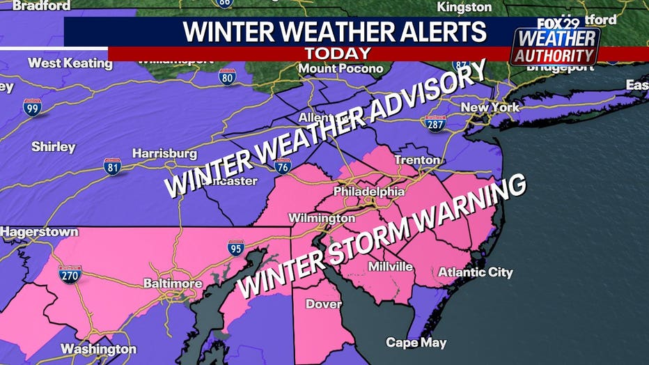
A Winter Storm Warning for southeastern Pennsylvania and southern New Jersey will remain in effect until 10 p.m., when its expected the storm will move offshore.
Counties to the far north and west of Philadelphia, including parts of Bucks County and across the river in Mercer County, are under a Winter Storm Advisory.
Several school districts across the region have canceled school Friday, and Philadelphia Mayor Cherelle Parker has declared a snow emergency.
While Friday's storm isn't supposed to be a major snowmaker, forecasters say it has the potential to dump up to 8 inches in some areas during the daylight hours.
Snowfall totals
Early snowfall totals gathered by the National Weather Service show most places have seen between 1-2 inches of snow as of lunchtime Friday.
FOX 29's Drew Anderson reported that accumulations in Philadelphia were around 2.5 inches Friday afternoon.
The largest snowfall totals so far have been in Delaware County, where a trained spotter reported 3.5 inches in Folsom and 2.5 inches in Thornton.
Over 2 inches have also fallen in nearby Chester County, where the weather service reports 2.6 inches in West Caln Township and about the same in East Nantmeal.
In New Jersey, the weather service says about 2.5 inches has fallen in Princeton and over 2 inches were recorded in Westampton Township.
Delaware snow totals appear to be on track with the rest of the region, with 2 inches reported in Newark and over an inch in parts of Kent County.
The National Weather Service provided an update on the snowfall totals, listing in order from highest to lowest:
Wilmington: 5.1"
WFO Mount Holly: 4.8"
Philadelphia Int'l: 4.6"
Atlantic City Int'l: 4.6"
Trenton-Mercer: 3.6"
Reading: 3.5"
Allentown: 1.6"
How long will the storm last?
Most of the region can expect to see flakes start to fall around 6 p.m. as the winter storm moves in from the south, starting slow and becoming more intense.
The storm will eventually spread to engulf the entire region by 9 p.m. and produce widespread snowfall through the afternoon and into the early parts of the evening.
Philly's single-day snowfall streak

Shoveling snow? Here are tips for doing it safely
The heavy snow forecast for the region means many will be out shoveling, but do you know how to keep safe while shoveling?
The National Weather Service on Thursday noted that it's been over 1,100 days since Philadelphia had 6 inches of snow fall in a single day.
They added that Philadelphia got 7.5 inches in January 2022 - over 700 days ago – but that storm spanned two days.
Philadelphia recently snapped a nearly two-year snow drought when just over an inch of snow blanketed the city for the first time in over 700 days.
What's next?
The snow is supposed to be contained to Friday, meaning Saturday will be a day dedicated to digging out of whatever mess is left behind.
While the snow may be gone, forecasters say the below-freezing temperatures will persist on Saturday with highs expected to be in the low 20s.
It may look warm outside over the weekend as bright sunshine is expected, but temperatures through Monday will barely crack the mid-30s.
The good news is that a thaw out is on the horizon. Forecasters expect temperatures to climb back into the 40s by Tuesday and the lower 50s by mid-week.
The catch? Forecasters believe rain will accompany the balmy temperatures on both Wednesday and Thursday to continue the region's wet weather pattern.