

Philadelphia snow forecast: Storm expected to bring snow, rain, mix Monday into Tuesday

Snow Watch: Sunday 10 pm forecast
FOX 29's Kathy Orr explains why folks may have to prepare for minimal inches of snow in the coming days.
PHILADELPHIA - This weekend may have seen a glimpse of spring, but it's already back to winter weather for the work week!
A potential snowstorm could impact the entire Delaware Valley with snow, rain and a wintry mix late Monday night into Tuesday, according to the National Weather Service.
All your Super Bowl Sunday plans are safe, as the transition to potential snow will begin Monday as temperatures drop into the 40s.
Soaking rain should start after dinner on Monday, until it becomes a mix, then snow around midnight.
The bulk of the snowstorm is set to begin at dawn Tuesday.
Snow is likely to fall in the Poconos, along with Philadelphia's north and west suburbs. A light wintry mix of snow and rain will cover Philadelphia and along the I-95 corridor into South Jersey.
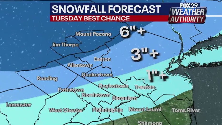
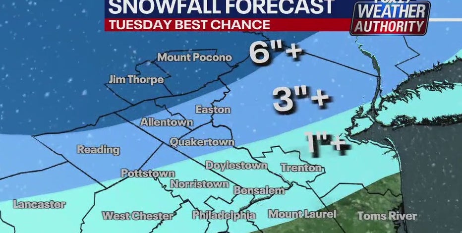
The highest snow totals are expected in the Poconos with 6 inches or more, and Berks/ Lehigh Valley and Upper Bucks with 3 or more inches.
Winter Storm Watches have already been issued for the Poconos, as well as Berks, upper Bucks, Lehigh and Northampton counties.
Forecasters do not believe the I-95 corridor will see much in the way of accumulating snow. Most of South Jersey will see mainly rain.
Philadelphia weather: Storm watches posted ahead of potential snowstorm Tuesday
A potential snowstorm could have some folks cuddling and watching snow fall by Valentine’s Day. Or, just shoveling snow.
In addition, a Coastal Flood Watch is in effect for moderate flooding along most of the Jersey beaches, and minor flooding along the Delaware beaches and inland along the Delaware River.
Compounding the precipitation and flood concerns, winds will pick up and be strong early Tuesday. Damaging wind gusts up to 30 to 40 mph are likely across the region throughout the day.