

Weather Authority: Temperatures remain frigid before late-week storm brings rain, snow

Weather Authority: 7 a.m. Tuesday forecast
Sue Serio has a look at this week's forecasts and when we will be seeing more snow and rain.
PHILADELPHIA - Tuesday is set to be another frigid day in the Delaware Valley as the FOX 29 Weather Authority team tracks a late-week storm that will bring wet weather.
No precipitation or inclement conditions are expected Tuesday, but temps will linger in the 30s but wind chills will make it feel close to the teens.
Looking ahead, forecasters say the storm system moving across the United States will cause delayed and canceled flights around Christmas.
Models project rain will move into the Delaware Valley Thursday afternoon and continue until Friday afternoon when precipitation changes over to freezing rain and even snow for some. Expect winds to pick up during that time as well with gusts as high as 40-50 mph Friday.
RELATED: 'High impact' Christmas week winter storm could lead to travel nightmare for millions of Americans
Gale-force winds and coastal flooding will be possible down the shore, while some snow accumulation is possible in the Poconos.
The system will move out of the area as conditions clear late Friday. Then, a blast of Arctic air will move in just in time for Christmas Eve.
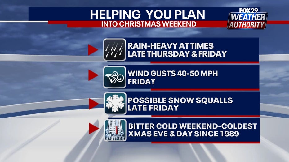
Expect high temperatures in the 20s both Saturday and Sunday with wind chills that feel like single digits.
According to the National Weather Service, if both Christmas Eve and Christmas Day don’t make it out of the 20s, it will be our coldest Christmas Eve and Christmas Day combination since 1989.
___
SEVEN-DAY FORECAST
TUESDAY: Sunny, cold. High: 40, Low: 28
WEDNESDAY: First day of winter. Sunny, cold. High: 42, Low: 25
THURSDAY: P.m. rain, breezy. High: 52, Low: 30
FRIDAY: Rain, brief snow. High: 58, Low: 52
SATURDAY: Christmas Eve. Arctic blast. High: 24, Low: 17
SUNDAY: Christmas Day. High: 27, Low: 16
MONDAY: Kwanzaa. High: 31, Low: 17