

LIVE| Blizzard Warning in Coastal NJ: How much is it going to snow in Philadelphia, New Jersey, Delaware?
PHILADELPHIA - A major winter storm is expected to impact the Philadelphia region Sunday into Monday, bringing heavy snow, strong winds and dangerous travel conditions across southeastern Pennsylvania, New Jersey and Delaware.
Philly snow storm: 10+ inches expected in the city
How much snow will Philadelphia get on Sunday? When will it start to snow? FOX 29's Drew Anderson breaks it down.
What we know:
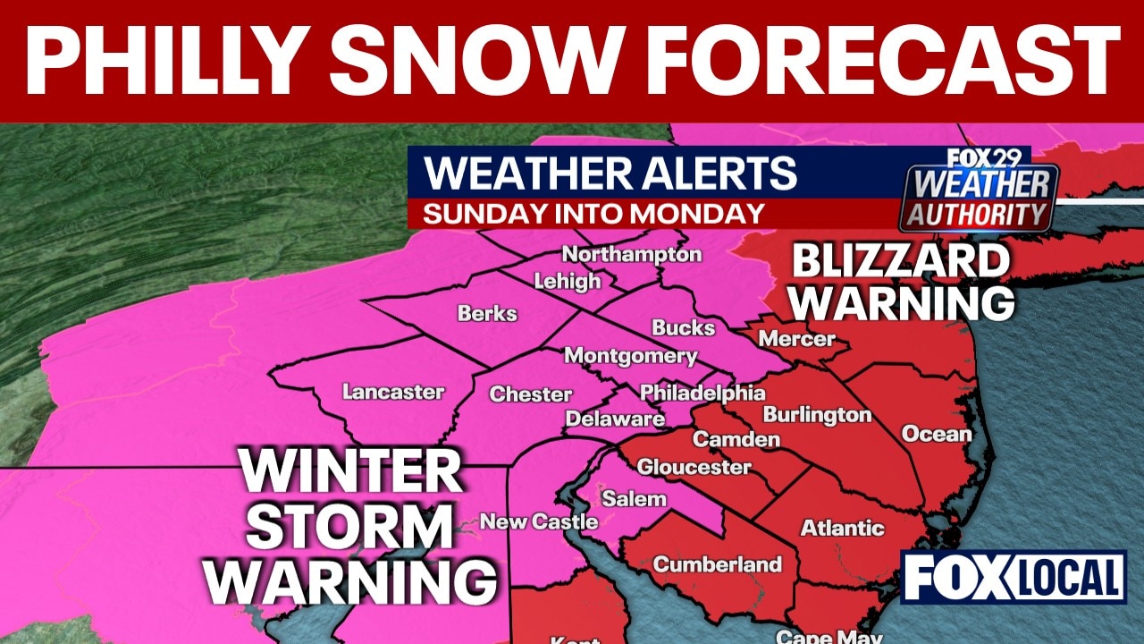
The National Weather Service has issued a Winter Storm Warning for Philadelphia from late Sunday morning through Monday evening.
Blizzard Warnings are in effect for Atlantic coastal New Jersey and Delaware, where the combination of heavy snow and strong winds could produce whiteout conditions.
Snow is expected to begin Sunday afternoon, possibly mixing with rain at the onset before changing fully to snow by late afternoon or early evening.
The heaviest snowfall is expected Sunday night into early Monday morning.

FIND THE LATEST WINTER WEATHER FORECAST HERE
Snow totals
- Philadelphia metro: 6–10 inches likely
- Interior South Jersey and northern Delaware: 8–12 inches possible
- Atlantic coastal New Jersey and Delaware: 12–18 inches possible, with locally higher amounts
Heaviest accumulations are focused across New Jersey and adjacent areas of southeastern Pennsylvania and northern Delaware.
Snowfall rates of 1 to 2 inches per hour are possible Sunday night, especially during the peak of the storm.

Wind and blizzard conditions
Northeast winds will increase Sunday evening.
- Inland gusts up to 35–40 mph
- Coastal gusts up to 50–55 mph
Blowing and drifting snow is expected, especially along the coast where blizzard conditions could make travel dangerous or impossible for several hours.
What this means for Philadelphia
Philadelphia is in the zone for significant snowfall, with projections around 12–18 inches.
Snow is expected to impact the Monday morning commute and potentially the Monday evening commute.
Snow-covered roads, reduced visibility and gusty winds are expected to cause widespread travel disruptions.
Philadelphia snow emergency, schools closed Monday
In anticipation of the storm, Philadelphia Mayor Cherelle Parker declared a snow emergency in the city.
Philadelphia School District Superintendent Dr. Tony B. Watlington, Sr. announced that all P

Timeline
Sunday morning:
Precipitation begins developing across the region. Some areas near and southeast of I-95 may start as rain before changing to snow by late morning or early afternoon.
Sunday afternoon:
Snow becomes steadier from north to south. Accumulations begin increasing across southeastern Pennsylvania, New Jersey and Delaware.
Sunday evening through early Monday morning:
Heaviest snowfall expected. Snowfall rates could reach 1 to 2 inches per hour, with locally higher rates possible. Strong winds increase, especially near the coast, leading to blowing and drifting snow and sharply reduced visibility.
Monday morning commute:
Snow-covered roads, poor visibility and gusty winds likely to cause significant travel disruptions.
Monday afternoon:
Snow tapers off from west to east, though lingering impacts and blowing snow may continue.
Monday evening:
Cleanup continues. Additional minor coastal flooding may be possible during subsequent high tide cycles.
Featured
What is a nor’easter and a bomb cyclone? How major East Coast winter storms form
After a weekend storm dumped snow across the Northeast, forecasters are again watching a system that could become a nor’easter or bomb cyclone. Here’s what those terms mean — and why this kind of storm can bring heavy snow, wind and coastal impacts.
Sunday travel
What you can do:
Experts are warning against traveling on Sunday if you can avoid it, but if you do need to PATCO trains will be operating on a regular Sunday schedule. During the storm though, trains will be operating at lower speeds.
PATCO will run a snow schedule on Monday, Feb. 23, starting at 4:30 a.m. The schedule can be found here.
Why you should care:
Widespread moderate to major impacts are likely with this storm, with the potential for extreme impacts along portions of the Atlantic coast.
Travel could become very difficult to impossible Sunday night into Monday morning.
Residents are urged to complete preparations Saturday, avoid unnecessary travel during peak storm hours and monitor updated forecasts.
Stay connected with FOX LOCAL. For 24/7 winter storm coverage—Download Now.
Stay ahead of the snow with FOX 29’s expert meteorologists on FOX LOCAL. Get the latest on the forecast, snow potential, and preparation tips. Download FOX LOCAL for 24/7 weather coverage on your smart TV and mobile devices.
The Source: This article was written using forecast information from FOX Weather and the National Weather Service.