

Philadelphia snow forecast: Winter storm alerts with rain turning into snow Monday into Tuesday

Weather Whiplash: Rain to wet snow Tuesday, visibility reduced
From temperatures in the 50s just last week, to a rainy/snowy Monday and Tuesday this week, Kathy Orr details everything you need to know ahead to prepare for the snow.
PHILADELPHIA - Parts of the Delaware Valley are bracing for a winter storm that forecasters believe will dump measurable snow in parts of the region overnight Monday into Tuesday.
The storm is part of a much larger system that promises to wallop New York and parts of New England with upwards of a foot of snowfall in some places.
Forecasters believe the storm's biggest impact on the Delaware Valley will be in areas far north of Philadelphia, including The Poconos and parts of the Lehigh Valley.
Most of the region can expect a wintry mix between Monday night and Tuesday, with snowfall totals dwindling the further south you live.
Warnings, watches and advisories
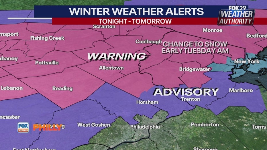
While only certain places are forecasted for major snow totals, every county across the Delaware Valley is still under at least one weather warning, watch or advisory.
The National Weather Service has issued a Winter Storm Warning for the Lehigh Valley, The Poconos and Reading.
Mercer, Middlesex and Morris counties in New Jersey, and parts of Bucks and Montgomery counties are under a Winter Weather Advisory.
With flooding a major concern for the incoming storm, Coastal Flooding Warnings and Advisories have been issued for southern New Jersey and all of Delaware.
The Atlantic coastal NJ & DE, DE Bay, and tidal DE River can expect minor to moderate coastal flooding and high tides through Tuesday night.
Timing out the storm

FOX 29's Sue Serio says the storm will start late Monday night as rain and gradually turn over to a wet slushy mix during the morning rush hour in Philadelphia.
In areas of higher elevation where the snowfall totals will be much higher, forecasters say the snow will start Monday night and last through Tuesday afternoon.
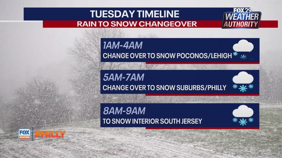
Forecasters believe the rain-snow line will ride the I-95 corridor, starting Monday night as rain and changing to snow that will hang around during Tuesday's commute.
Whether you get snow, rain or both, forecasters believe the storm will mostly wrap up Tuesday afternoon.

Breakdown of Wintry mix Monday into Tuesday
FOX 29's Kathy Orr and Scott Williams gives a full breakdown of what to expect in weather ahead snow Tuesday.
Snow totals
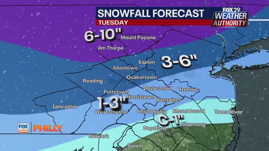
How much snow you can expect depends on where you live.
Forecasters say the Poconos, Lehigh Valley and surrounding areas will bare the brunt of Tuesday's storm with between 6-10 inches of snowfall.
Places to the northeast of Philadelphia should brace for 3-6 inches, while Trenton, Bucks County and Montgomery County should expect up to 3 inches.
Philadelphia and surrounding areas should expect 1-3 inches, while southern parts of New Jersey can prepare for a dusting or rain that could measure around an inch.
Wind gusts
Along with snow and rain, forecasters are predicting some strong wind gusts that will be the most intense along New Jersey's coast.
Forecasters say winds will blow above 30 MPH in Philadelphia and surrounding areas, and even slightly stronger in parts of interior New Jersey.
Wind gusts will be far less powerful in areas to the far north and west of Philadelphia where the snowfall totals are expected to be higher.
Coastal New Jersey should brace for the storm's strongest wind gusts that could be above 40-50 MPH which may result in isolated wind damage and power outages.
School closures
As the storm inches closer to our area, be sure to stay on top of any modifications school's make to their instructional day.

Philadelphia school closings: Delays, cancellations ahead snow fall across region
Schools in the Philadelphia area are preparing for another potential snowfall, some with delayed start times, and others with complete closings.
Check out FOX 29's Closings and Delays page for up-to-the minute updates from school district's across the region.