

Philadelphia weather: Storms and wind could bring severe weather Sunday evening

Weather Authority: Sunday 10 pm forecast ahead overnight showers
FOX 29 Meteorologist Kathy Orr breaks down what to expect in weather as storms make their way over to the Philly area overnight Monday.
PHILADELPHIA - Sunday will be a dry day, though windy, so the luck of the Irish shines on Philadelphia's St. Patrick’s Day parade. But, later in the day, rain and some thunderstorms will move into the region.
What we know:
A cold front is making its way to the Philadelphia area. It’s the same system that has brought devastation to the Midwest and the South, resulting sadly in deaths, due to tornadoes.
While we won’t see the same devastating impacts, some severe weather is possible and an isolated tornado can’t be ruled out.

St Patrick's Day 2025: Will it rain on Philly's St Patrick's parade?
Philadelphia’s annual tradition of celebrating St. Patrick’s Day with a parade is set for Sunday. But, will the weather rain on the parade?
Sunday:
Most of Sunday will be dry, but very windy. Temperatures will reach the mid to upper 60s, but with the strong wind gusts, it will feel cooler.
If you’re heading to the parade, the winds will be very strong, so dress appropriately for that.
A wind advisory is in effect in the Philadelphia area until 9 p.m. and until 11 p.m. in parts of central and southern Delaware, and central and southern New Jersey.
According to the National Weather Service, south winds can reach 15 to 25 mph with anticipated gusts of 40 to 50 mph in the Philly area.
Expect tree limbs to be blown around, and power outages.
PHL Airport

PHL Airport flight delays due to strong winds
Over 300 flights were delayed at Philadelphia International Airport Sunday due to strong winds prompting frustration among travelers.
The Philadelphia International Airport (PHL) has announced flight delays due to winds Sunday.
Passengers are advised to check with their airlines for updated flight information.
According to the NWS, PHL Airport reached 70° for the first time this year.
Stormy weather:
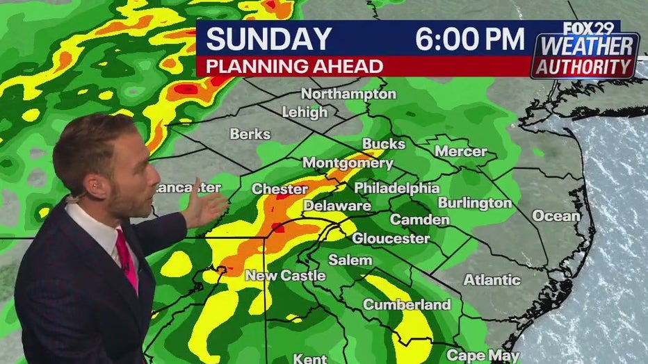
Storms will begin to move into the region by late afternoon, approaching from the west.
The storms will continue to push west to east, and the main threat will likely be damaging wind gusts. The rain will take its time pulling offshore, lingering into early Monday morning.
According to the National Weather Service Mount Holly, the greatest risk severe weather remains across eastern PA and the Delmarva.
Flash flooding could be expected in some areas due to heavy downpours.
What's next:
Monday morning will likely see some leftover rain showers and windy conditions, before skies clear out for Monday night. Temps will likely only reach the middle 50s.
Most of the week will see pleasant conditions, with highs in the mid to upper 60s and sunny skies.
Thursday will be the next rain chance, ahead of a steep drop in temps for Friday, as another front moves in, bringing blustery conditions and temperatures only in the mid-40s.
What you can do:
For the latest forecasts and conditions, download the FOX 29 Weather Authority app.