

Philadelphia weather: Severe thunderstorm, flood watch issued in Pennsylvania, New Jersey and Delaware
PHILADELPHIA - Clouds fill the sky Sunday as that muggy feeling is expected to turn into severe weather as possible storms roll into the region just after dinnertime.
The sun peaked through the clouds shortly Sunday morning, energizing the atmosphere, and setting the region up for thunderstorms and possible severe weather through the evening.
These storms have the potential for frequent lightning, damaging wind gusts and even a little hail.
The National Weather Service issued a severe thunderstorm watch for parts of Pennsylvania, New Jersey and Delaware until 7 p.m. Sunday.
A flash flood warning has also been issued for Southwestern Philadelphia, West Central Burlington, Camden, Northeastern Gloucester, and East Central Delaware Counties until 9 p.m. Sunday.
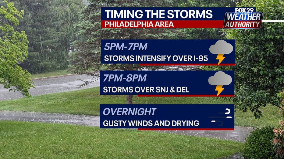
Storms will continue to intensify until 7 p.m. once it then reaches Delaware. Expect gusty winds overnight into Monday.
That severe weather should push off the Jersey shore around dinnertime and will usher in much more comfortable air for Monday.
Sunday temperatures will reach into the lower 90s, before the storms roll in. The National Weather Service has issued a Heat Advisory for Sunday between 11 a.m. and 7 p.m.

Monday will be pleasant, under mostly sunny skies and temps around 80 degrees.

Looking ahead to July 4th, the day promises to be hot and humid, with highs in the low to mid-90s. A stray shower is possible as well, but it’s not a widespread event and should not disrupt fireworks displays.
_________
SUNDAY: Afternoon storms. High: 92, Low: 66
MONDAY: Sunny, less humid. High: 82, Low: 62
TUESDAY: More humid. High: 84, Low: 66
WEDNESDAY: Hot and humid. High: 88, Low: 70
THURSDAY: July 4th. High: 94, Low: 74
FRIDAY: More storms. High: 92, Low: 74