

Snow Forecast: Nor'easter to bring several inches of snow to Delaware Valley Friday, Saturday
PHILADELPHIA - A powerful nor'easter that plowed into the Delaware Valley on Friday night continued overnight with heavy snow and whipping winds that will last for most of Saturday. While most of the region will receive significant snowfall totals, forecasters believe coastal areas could see a foot or more.
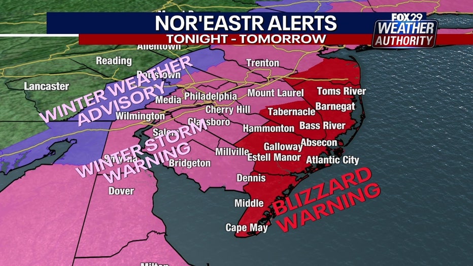
The National Weather Service has issued Winter Storm Warnings for parts of our area including the I-95 corridor and everywhere to the south and east. Blizzard Warnings will also be going into effect for areas down the shore, while Winter Storm Watches are in effect for areas to the north and west of the I-95 corridor.
The weather advisories went into effect at 7 p.m. Friday and won't expire until the snow subsides on Saturday night. Areas under the Blizzard Warning should brace for snowfall between 12 and 18 inches, and wind gusts up to 50 miles per hour, according to the National Weather Service.
The National Weather Service warns that travel in areas under the Blizzard Warning could be ‘very difficult to impossible’ as blowing snow could reduce visibility and gusty winds could bring down tree branches. Blizzard conditions are primarily expected at or withing a few miles from the coast.
New Jersey Gov. Phil Murphy declared a state of emergency on Friday and asked residents to stay off the roads if possible. Likewise, Philadelphia issued a Snow Emergency during which Center City PPA-owned parking garages will offer $5 parking.
How much snow will we get?
Forecasters believe the nor'easter will bring the most significant snowfall totals along the coast and become progressively less severe as you move inland.
The FOX 29 Weather Authority predicts that coastal regions of New Jersey and southern Delaware will bear the brunt of the winter storm, with between 12 and 16 inches of snow piling up. The sharp cutout of the Jersey Shore by Long Beach Island and Tom's River could see over 16 inches.
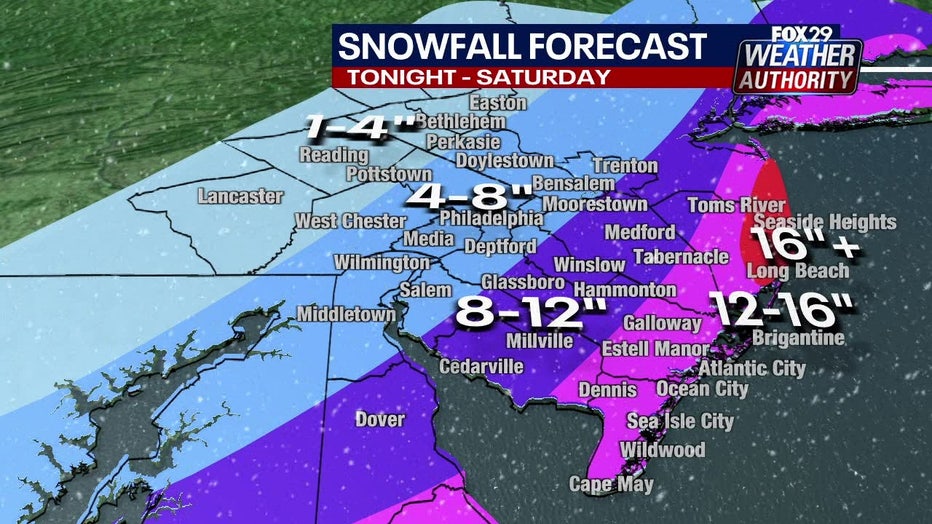
A large portion of interior New Jersey - including areas just south and east of the I-95 corridor and most of Delaware - should expect anywhere from 8-12 inches of snow.
The Philadelphia area and I-95 corridor won't see extraordinary snowfall totals, but will still receive a significant coating between 4-8 inches.
Areas north and west of Philadelphia should see the lightest accumulations between 1 and 4 inches.

Weather Authority: Friday, 11 p.m. update
FOX 29's Kathy Orr and Scott Williams have your snow forecast.
When will the snow stop?
Following an appetizer of pre-nor'easter flurries on Friday, the winter storm plowed into parts of the Delaware Valley around dinnertime with light-to-moderate snowfall across most of the region
The National Weather Service on Friday night pointed out a high-intensity band of snow that formed slightly more inland from the coast than forecasters previously envisioned. The weather service said conditions will rapidly deteriorate within the band as it moves slowly to the north overnight.
Forecasters say the snow will pick up in intensity overnight, falling at a rate of 1-to-2 or more inches per hour in some places. FOX 29's Scott Williams adds that the height of the nor'easter will be between 2 a.m. and 9 a.m. Saturday morning.
The snowstorm will continue to churn on Saturday morning with the heaviest snowfall continuing to batter the coastal areas of New Jersey and Delaware. Steady snow is expected to coat interior parts of New Jersey, Delaware, and a portion of southeastern Pennsylvania throughout the morning.
Forecasters expect the snow to taper off during the middle of the afternoon on Saturday, leaving just enough daylight to start digging out.
Wind and coastal flooding threats
Strong winds will be possible from Friday night through Saturday, potentially causing blowing and drifting snow. Those conditions could create very low visibilities, especially along the Delaware and New Jersey Coasts.
Wind chills will also be frigid, with temperatures already forecasted to be in the 20s Saturday. Dangerous wind chills are expected Saturday night and into Sunday morning.
Minor coastal flooding is expected Saturday morning along portions of the New Jersey and Delaware coasts. The National Weather Service says the maximum storm surge is about 1.5 to 2 feet, and that any flooding should be minor thanks to fortunate timing.
Coastal Flood Warnings go into effect at 2 a.m. Saturday morning in Cape May County, New Jersey and Sussex County, Delaware.
Gale Warnings have also been issued in areas off the coast.
For the latest forecasts and conditions, download the FOX 29 Weather Authority app.
___
RELATED HEADLINES:
- Nor'easter incoming: Blizzard Warnings issued from Maine to Virginia ahead of heavy snow, winds
- What makes a storm a nor’easter?
- Here’s what you should keep inside your car in case of an emergency
- Here's what to have on hand if the power goes out during a winter storm
___
DOWNLOAD: FOX 29 NEWS APP | FOX 29 WEATHER AUTHORITY APP
SUBSCRIBE: Good Day Digest Newsletter | FOX 29 Philly on YouTube