

Philadelphia weather: Severe thunderstorm warning, wind advisory issued as strong storms threaten region
Severe Thunderstorm Warning issued in the Philadelphia region: What we know
FOX 29 Meteorologists Kathy Orr and Scott Williams have the latest on the severe weather Monday night.
PHILADELPHIA - Philadelphia is bracing for a round of wet, and potentially dangerous, weather on Monday with heavy downpours and strong winds.
The National Weather Service had issued a Tornado Watch for the entire region from 11 a.m. until 7 p.m. However, that watch was lifted at 6 p.m.
Residents in the Kent County, Delaware area are urged to take cover as a Tornado Warning is in effect until 11 p.m.
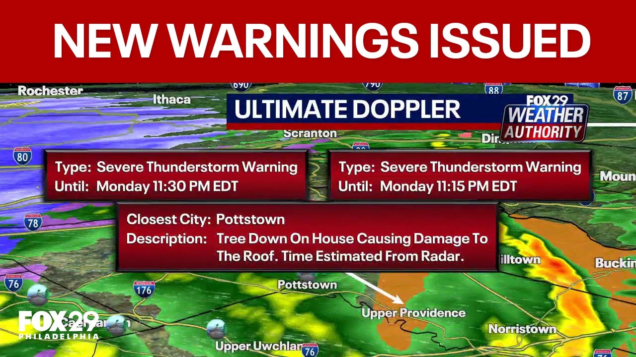
The NWS also issued a Severe Thunderstorm Warning in the Philadelphia area until 11:30 p.m. Monday.
When will it rain?
What we know:
Rain will be with us throughout the day, starting as spotty showers during the morning and afternoon before becoming widespread.
The brunt of the storm is expected to happen around 5 p.m. when heavy bands of storms will roll across the Philadelphia area.

Showers, with bouts of heavy downpours and pockets of strong thunderstorms, will continue throughout the evening hours.
The storm is expected to begin to wind down around midnight, with wrap around moisture from a cold front that could bring flurries.
Tornado Watch
What they're saying:
Forecasters expect strong wind gusts to be among the greatest threats associated with the storm.
The National Weather Service issued a Tornado Watch for the entire region from 11 a.m. until 7 p.m. The watch was lifted by 6:00 p.m.
The weather advisory warns of potential wind gusts up to 80 MPH and isolated bouts of quarter-sized hail.
The alert supersedes a previous Wind Advisory issued by the weather service earlier in the day.
As of 10:30 p.m., the NWS issued a Tornado Warning for Kent County, Delaware that will remain in effect until 11:00 p.m. Monday.
Severe Thunderstorm Warning
A Severe Thunderstorm Warning is in effect in the Philadelphia region until 11:30 p.m. Monday.
The area includes Camden, West Chester, Norristown, Chester, Phoenixville, Lansdale, West Norriton, East Norriton, Yeadon, Westtown, Quakertown, Perkasie, Doylestown, Byram, Conshohocken, Hatboro, Souderton, Folcroft, and Bedminster.
Wind gusts are reported up to 60mph with some gusty showers included as well.
Tornadoes can develop from severe thunderstorms. Therefore, the NWS urges anyone who may spot a tornado to go into a basement or a small central room in a sturdy structure.
Wind Advisory
A Wind Advisory remains in effect until 2:00 a.m. Tuesday for portions of central, northern, and southern Delaware, southern New Jersey, and east central, northeast, and southeast Pennsylvania.
Winds are expected to reach 25 to 35 mph with gusts up to 50 mph.
With these strong winds, the NWS urges drivers to use extra caution and warn residents to secure any outdoor items.
How much will it rain?
By the numbers:
Forecasters expect Philadelphia and its suburbs to receive anywhere between 1"-1.5" of rain on Monday.
That will be enough for localized flooding of low-lying creeks, streams, and other bodies of water.
Stay ahead of the storm
What you can do:
Stay up-to-date on the latest forecast from the FOX 29 Weather Authority by downloading the free FOX LOCAL app.