

Philadelphia weather: Severe thunderstorm warnings issued for parts of Pennsylvania, NJ, Delaware
PHILADELPHIA - After record-setting heat in Philadelphia on Wednesday, much of the region is under a severe weather watch Wednesday evening.
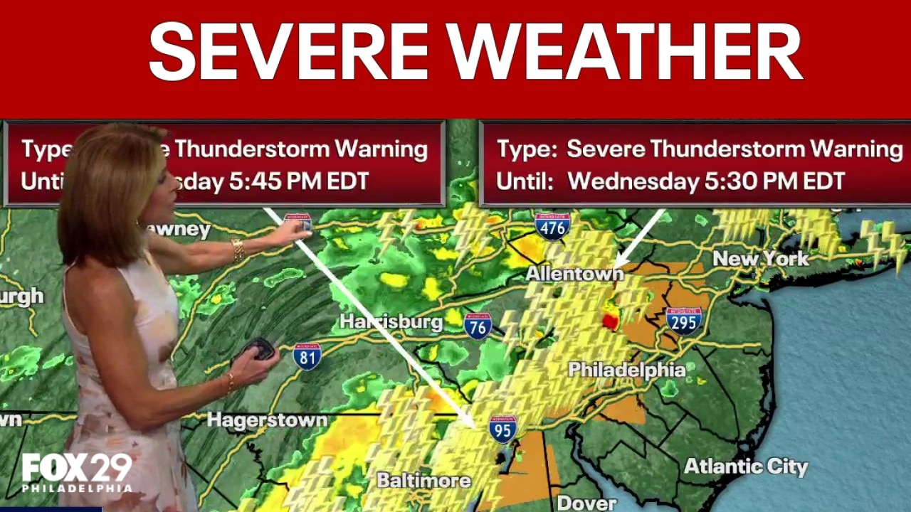
Severe thunderstorm warnings
What we know:
Philadelphia weather: Severe Thunderstorm Warning in effect
FOX 29 meteorologist Kathy Orr breaks down tonight's Severe Thunderstorm Warning and looks ahead at the 7-day forecast.
The National Weather Service issued several severe thunderstorm warnings across the region Wednesday evening. They include:
- The Allentown, Bethlehem, and Easton areas through 5:30 p.m.
- The Philadelphia, Chester and Camden, New Jersey, areas through 6 p.m.
- The Levittown, Trenton and Norristown areas through 6 p.m.
- The Middletown, Delaware area through 6 p.m.
Earlier Wednesday, the NWS issued a severe thunderstorm watch for most of southeastern Pennsylvania including Philadelphia, Berks, Bucks, Delaware, Chester, Lehigh and Montgomery Counties, as well as all of Delaware and New Jersey.
The watch is in effect from 2 p.m. to 9 p.m. on Wednesday.
NWS forecasters say there are three major concerns for Wednesday evening — potential hail, wind and lightning. According to officials, isolated, quarter-sized hail, wind gusts up to 70 mph and frequent lighting are all possible throughout the watch zone.
Flash Flood Warning
In addition to the severe thunderstorm warning, the NWS has issued a Flash Flood Warning for the following areas until 9:45 p.m. Wednesday:
- Northwestern Burlington County
- Northwestern Camden County
- North Central Gloucester County
- Southeastern Bucks County
- Delaware County
- Southeastern Montgomery County
- Philadelphia County
SEPTA
Due to severe storm damage, including downed trees and loss of signal power, service is experiencing system-wide delays of up to one hour.
Thorndale and West Trenton have been suspended until further notice.
Find alternate routes here or use the Trip Planner on SEPTA.org or in the SEPTA App.
Storm Damage
Downed trees have been reported across the outer Philadelphia area.
See pictures below of storm damage on Mervine Street in Lower Pottsgrove, Montgomery County, where a massive tree rushed the roof of a two-story colonial home.
See several trees down on Buchert Road in Lower Pottsgrove:

What you can do:
The NWS recommends people living in these areas to follow the latest forecasts and to make sure you can receive alerts about severe weather watches and warnings.
Memorial Day Weekend forecast
What's next:
Pockets of storms are expected to continue overnight Wednesday and could leak into early Thursday morning.
Thursday will be a preview of what's expected to be a wet and chilly Memorial Day Weekend in the Philadelphia area. Temperatures will only reach 63 degrees with showers around all day. Sunshine will reemerge on Friday while temps remain chilly.
Memorial Day Weekend will kick off with a raw and rainy Saturday, with highs only set to reach 56 degrees. Showers will remain on Sunday and Monday with slightly warmer temperatures each day.
The Source: Information in this story is from the National Weather Service and the FOX 29 Weather Authority.